

Severe Tropical Cyclone Oma could possibly cross the southern Queensland coast, after changing direction overnight, the Bureau of Meteorology (BOM) says.
The category two system is currently off New Caledonia, about 1,100 kilometres north-east of Brisbane, where it has caused some coastal damage and flooding. BOM said it was no longer expected to turn south-east towards New Zealand over the weekend.


Forecaster Sam Campbell said instead the system was moving south-west.He said a cyclone watch may be issued this afternoon ahead of gale force winds developing tomorrow.
“It’s now looking increasingly likely that it will continue on a westerly track towards the southern Queensland coast,” he said.
“Most likely it will weaken just a touch, it won’t be a category three by the time it gets to the coast, but just to emphasis that point — we could actually see that cyclone coming into southern Queensland and possibly even a coastal crossing over the weekend.”
Space to play or pause, M to mute, left and right arrows to seek, up and down arrows for volume.
“Anywhere south of about St Lawrence, so that’s that area around Rockhampton, so anywhere south of there right down to Brisbane really is potentially in play for a cyclone crossing if that was to occur — but I’ve got to emphasise it will come near the coast and not necessarily cross the coast but it is possible it could cross the coast.”
BOM warned abnormally high tides and dangerous surf conditions are expected along the Queensland coast from the town of 1770 to Coolangatta in the coming days.
It said dangerous surf conditions would develop on Thursday afternoon in the Fraser Island and Capricornia areas.
“These conditions are then expected to extend south over remaining south-eastern Queensland coastal waters during Friday,” BOM said.
“Beach erosion is likely to continue with the hazardous marine conditions.”
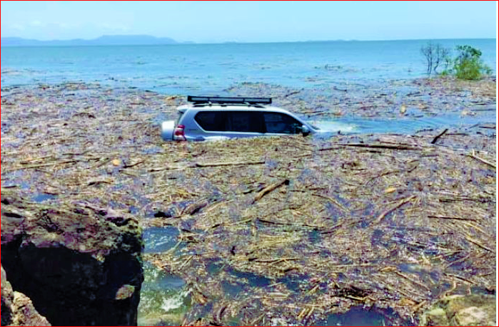
Yesterday’s king tide along coastal areas north of Mackay caused some erosion at Midge Point and the Pioneer River to flow into the nearby carpark.
Today’s high tide is forecast to exceed the highest tide of the year by around half a metre.
Water Police Senior Sergeant David Edden said people should avoid any type of boating and water activities near surf-exposed areas for at least the next five days.
“All boaties, fishers, surfers and swimmers should reconsider any plans which involve the surf over the coming days,” he said.
“It is also vital to check the security of your anchored vessel and ensure it is prepared for extreme winds and damaging swell.
“Those already on the water should ensure they are carrying the appropriate safety equipment and are wearing lifejackets.
“[They should] remember to log on with their local radio base and consider their safety management plan.”
Gold Coast lifeguards are expected to close beaches as the swell increases.
Fencing has been removed from some Gold Coast beaches and the city’s council has heavy machinery on standby to reprofile beaches and move sand to vulnerable locations.

On the Sunshine Coast, Mooloolaba’s fishing fleet has largely returned home ahead of the system.
Mooloolah River Fisheries general manager Daryn Logan said only the bigger tuna boats and trawlers remained at sea and they were expected home within a day.

“At the moment it’s totally unpredictable, so as soon as they know where that’s gone or what it’s doing, they’ll get out there,” Mr Logan said.
“In the meantime, the fishing grounds just get a bit of a forced rest.”

Bargara surfing instructor Keith Drinkwater said conditions would be assessed daily but classes were likely to be cancelled for the rest of the week.
“A lot of sand erosion is going to occur but we just hope there’s no damage, but nature takes its own course,” he said.

“We have some classes booked every day but we’ve been very careful with what we do at the moment.
“It could be fantastic for surfers over the next three or four days. “I’d hate to see learners and intermediate surfers go out there … you’ve got to be able to surf in your own means.”With ABC News


