

After multiple years of flooding rains, people have had enough. But the Bureau of Meteorology’s severe weather outlook indicates we are going to have to keep picking ourselves back up again this season.

The outlook warns of an increased risk of widespread flooding for eastern and northern Australia and an increased risk of an above-average number of tropical cyclones and tropical lows.


It finds normal bushfire potential in eastern states but an elevated risk of grass fire in southern Australia, and increased risk of prolonged heatwaves in southern areas, along with higher humidity.
There is a normal risk of severe thunderstorms but a possible increase in risk of thunderstorm asthma events if conditions are dry in late spring and early summer.
The combination of La Niña conditions in the Pacific Ocean and a negative Indian Ocean Dipole in the west means warm waters are fuelling these wet conditions from both sides and encouraging an early start to the northern wet season.
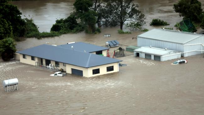
Now in the third La Niña year in a row — with rivers, dams and soil up and down the coast already brimming — it isn’t taking much to trigger floods, as we saw this weekend.
Most of the country is enjoying a brief respite from the relentless rain today but water is still streaming its way down creeks and rivers, especially in New South Wales.
The next round of rain is expected from Tuesday night. More on the forecast below.
Judging from this outlook, it will be just one of many more rounds to come. abcnews


